Map skills are one of those learning areas that get stronger through repetition. Children need to see countries, trace coastlines, compare regions, notice borders, and come back to the same places again and again. A video can introduce geography, and an app can quiz it, but there is still something powerful about putting a real map on the table and asking a child to point, trace, label, erase, and try again.
That is why screen-free geography practice is having a useful moment. Families want learning tools that do not add another login. Teachers want materials that work when the Wi-Fi is slow, the projector is booked, or a small group needs something hands-on. Homeschool parents want a simple way to build background knowledge without turning every lesson into prep. A laminated study map hits a sweet spot because it can be used quickly, repeatedly, and in a lot of different ways.
The goal is not to memorize every place on earth in one sitting. The goal is to build geographic confidence. Kids should understand that maps are tools for thinking. They show relationships, distance, direction, climate, culture, borders, and movement. When map practice becomes routine, children begin noticing how geography connects to history, science, reading, and current events.
Why hands-on map work still matters
Many children can pinch and zoom on a screen, but they still struggle to hold a mental picture of where places are in relation to one another. A physical map slows the process down. The child has to scan, compare, and decide. They can place a finger on one country and another finger on the ocean beside it. They can see that Europe and Africa are close at the Mediterranean, that Asia is enormous, or that South America stretches much farther south than many children expect.
This kind of spatial awareness is hard to rush. It grows through repeated looking. Dry-erase practice adds another layer because children can test themselves without fear of ruining the page. They can label five countries, erase, then label five more. They can draw arrows for trade routes, migration, explorers, weather patterns, or story settings. The map becomes active instead of decorative.
If you are building a geography area, start with the Geography and Maps collection or the broader Study Maps collection. A world map is a strong anchor, then you can add continent or country maps as children need more detail.
Use the two-side method
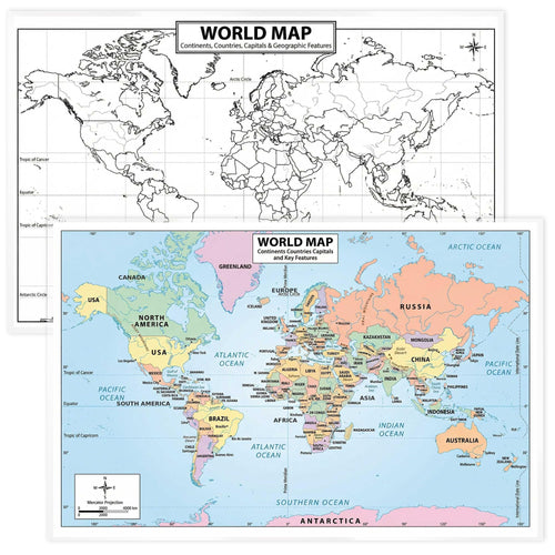
A very simple routine is to use one side for looking and one side for recall. With a double-sided study map, children can study the full-color side first. They point to the title, compass, key details, borders, labels, and surrounding water. Then they flip to a blank or outline side and try to rebuild what they noticed.
This is more useful than passive copying. The flip creates a small retrieval challenge. The child has to pull information back from memory. If they cannot remember, they flip back, check, and try again. That cycle of look, hide, recall, check, and correct is where a lot of learning sticks.
The 2026 Updated World Map Poster is built for exactly this kind of practice. It works as a wall reference, a table activity, a homeschool geography anchor, or a quick review station. Because it is laminated, kids can use dry-erase markers to label oceans, continents, equator, prime meridian, country names, capitals, or travel routes.
Turn map practice into five-minute routines
You do not need a full geography lesson every time. In fact, short routines often work better. Try a five-minute map warmup before history, social studies, reading, or even science. Ask one focused question: Where is this place? What is nearby? Which ocean touches it? Is it north or south of the equator? What route might someone travel to get there?
Small prompts make maps feel useful. If a class is reading about ancient Egypt, point to northeast Africa and trace the Nile. If a child is learning about weather, compare climates around the equator and poles. If a book mentions Japan, find the islands and talk about surrounding water. Geography should not live in its own box. It should pop up whenever place matters.
For homeschool families, make the map part of morning time. Choose one country per day. Find it, say the continent, notice a border or water feature, and write one fact. After a month, children will have touched dozens of locations without a heavy curriculum block.
Build confidence with blank map challenges
Blank maps can feel intimidating if you start too big. Make them friendly by narrowing the task. Instead of "label Africa," try "label three countries you know and circle one you want to learn." Instead of "fill in all of Europe," try "mark the United Kingdom, France, Spain, and Italy." Kids should feel the blank space as an invitation, not a test they are destined to fail.
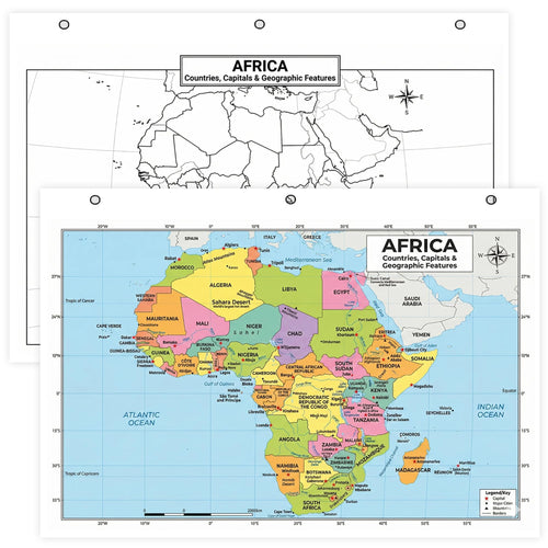
The Africa Map laminated chart is a good example of how continent maps can support gradual mastery. Children can start with large, high-recognition features, then build toward more detailed country and region knowledge. One day might focus on north, south, east, and west. Another day might compare coastal and landlocked countries. Another might connect geography to animals, biomes, languages, or history.
Dry-erase tools are forgiving. A child can make mistakes, wipe them away, and try again. That matters because geography can become discouraging if every error feels permanent. Reusable maps turn the process into practice.
Pair maps with stories
One of the easiest ways to make geography stick is to connect it to stories. When children hear about a place in a book, news story, family trip, recipe, historical event, or science topic, find it on the map. The map gives the story a location, and the story gives the location meaning.
For example, if you are learning about the Bill of Rights, locate the United States and talk about the thirteen colonies. If you are studying rainforests, find the Amazon Basin, Central Africa, and Southeast Asia. If a child is reading a novel set in London, find the United Kingdom, then zoom out to Europe and the Atlantic. This habit builds background knowledge quietly over time.
Jelly Bean Genius study tools are designed for this kind of cross-subject use. You can browse History and Government, Science, and Geography and Maps together because students rarely learn in neat subject boxes. A good wall map can support all three.
Try map stations in the classroom
For teachers, maps make excellent station work. Set up one map station with a laminated map, markers, task cards, and a wipe cloth. Students rotate through in pairs or small groups. One group labels oceans. Another traces a route. Another compares two regions. Another writes three observations. Because the map is reusable, you do not need a fresh worksheet for every group.
A station can also support early finishers. Instead of sending students to a screen or a random packet, give them a map prompt. Find three countries that start with B. Draw a route from New York to Tokyo. Circle a country that is landlocked. Label the equator and one country it crosses. These little tasks build map fluency without requiring a full lesson reset.
If you are planning a larger classroom setup, visit For Teachers or contact the team for bulk classroom sets. Laminated tools are especially useful when the same material needs to survive stations, tutoring, small groups, and repeated review.
Shop the map practice idea
Start with a strong wall or table anchor from Study Maps. Add continent or topic maps from Geography and Maps as your child or class needs more detail. If you are building by subject, the Shop by Subject page is a quick way to browse geography alongside history, math, science, and computer skills.
Screen-free map practice does not have to be old-fashioned. It can be active, quick, and flexible. Put a map where children can touch it. Give them a marker. Ask one good question. Then let them look, label, erase, and try again.
Quick FAQ
How often should kids practice maps? Short practice two or three times a week is better than one long session once in a while. Five minutes can be enough if the task is focused.
What should we learn first? Start with continents, oceans, compass directions, and the places connected to your current reading or social studies topic. Add capitals and details later.
Are laminated maps worth it? Yes if you plan to reuse them. Dry-erase practice lets children make mistakes, correct themselves, and repeat without burning through worksheets.
Can maps help with reading? Absolutely. Finding story settings on a map builds background knowledge and helps children understand distance, culture, and context.
What is a good first product? A world map gives the broadest use. Then add continent maps or subject-specific charts based on what your child or class is studying.
How to use this this week
The easiest way to turn this idea into action is to pick one small routine and repeat it for five days. Do not rebuild the whole room, rewrite the whole lesson plan, or buy every possible material at once. Choose the part of the day that already needs support and place the visual tool there. Morning warmups, small-group rotations, homework time, quiet reading, and end-of-lesson review are all good candidates because children already expect a routine in those moments.
On day one, model the routine yourself. On day two, let a child help. On day three, ask students to explain the steps back to you. On day four, use the tool with a slightly harder prompt. On day five, keep the tool available and notice whether children reach for it with less adult direction. That simple progression gives the visual a real job instead of leaving it as another nice-looking item on the wall.
If you are teaching a group, write the prompt on the board before students arrive. If you are using the idea at home, put the prompt on a sticky note beside the material. The less you have to explain in the moment, the more likely the routine is to happen. Small routines are where map practice starts to feel natural.
What to buy first
Start with the product or collection that supports the routine you will actually repeat. If the challenge is reference and recall, choose a laminated study tool. If the challenge is classroom flow, choose a visual that sits near the transition point. If the challenge is building background knowledge, choose a map or subject chart that can stay visible all week. You can always build out the set later.
Useful internal starting points include Study Maps, Geography and Maps, and Shop by Subject. Those pages keep the browsing focused around practical classroom and home use, which is better than collecting random resources that never make it into the routine.
A four-week map skills starter plan
Week one can focus on the big picture: continents, oceans, compass directions, and the equator. Keep the questions broad and physical. Point, trace, circle, erase, and repeat. Week two can add countries or regions that connect to whatever children are reading or studying. If a story mentions a place, find it. If a history lesson names a country, locate it. If a science topic talks about climate, look at where that climate appears on the map.
Week three can move into blank-map recall. Ask students to label only a few items at a time, then flip back and check. Week four can add comparison prompts: which place is farther north, which country is landlocked, which route crosses an ocean, or which region might have a warmer climate. The plan stays light, but the repeated handling builds real fluency.